U - Z
UTC – The World’s Time Standard:
Coordinated Universal Time (UTC) is the basis for civil time today. This 24-hour time standard is kept using highly precise atomic clocks combined with the Earth's rotation.
UTC is the time standard commonly used across the world. The world's timing centers have agreed to keep their time scales closely synchronized - or coordinated - therefore the name Coordinated Universal Time.
Two components are used to determine UTC:
-International Atomic Time (TAI): A time scale that combines the output of some 400 highly precise atomic clocks worldwide, and provides the exact speed for our clocks to tick.
International Atomic Time is an extraordinarily precise means of time-keeping. Atomic clocks deviate only 1 second in about 20 million years. The secret to this impeccable precision is the correct measurement of the second as the base unit of modern time-keeping. The International System of Units (SI) defines one second as the time it takes a Cesium-133 atom at the ground state to oscillate exactly 9,192,631,770 times. Atomic clocks are designed to detect this frequency, most of them today using atomic fountains. To achieve the highest possible level of accuracy, the International Bureau of Weights and Measures combines the output of about 400 atomic clocks in 69 national laboratories worldwide to determine TAI. The time scale is weighted, prioritizing the time signal provided by institutions that maintain the highest quality of primary cesium. The high level of precision achieved by using atomic clocks is both a blessing and a curse. On the one hand, accurate time-keeping is a necessity, for example for time-sensitive technology, such as modern air traffic control systems that rely on satellite navigation. On the other hand, TAI does not take into account the Earth's slowing rotation, which determines the length of a day. For this reason, TAI is constantly compared to UT1. Before the difference between the two scales reaches 0.9 seconds, a leap second is added to UTC.
-Universal Time (UT1), also known as astronomical time or solar time, refers to the Earth's rotation. It is used to compare the pace provided by TAI with the actual length of a day on Earth.
Universal Time (UT) was created at the Washington Meridian Conference in 1884. This is the basis for the 24-hour time zone system we know today.
At the time, Greenwich Mean Time (GMT) was chosen as the world’s time standard. The reference line or starting point, the Prime Meridian, was determined to be the transit circle at the Royal Observatory in Greenwich, London. The transit circle is a part of the telescope's mechanics and it is still cited as the Prime Meridian's original reference. In 1960, the International Radio Consultative Committee formalized the concept of UTC, and it was put into practice the year after. The name Coordinated Universal Time was officially adopted in 1967. Until 1972, Greenwich Mean Time (also known as Zulu time) was the same as Universal Time (UT). Since then, GMT is no longer a time standard. Today, Greenwich Mean Time is only the name of a time zone that is used by a few countries in Africa and Western Europe, including the UK during winter and all year in Iceland
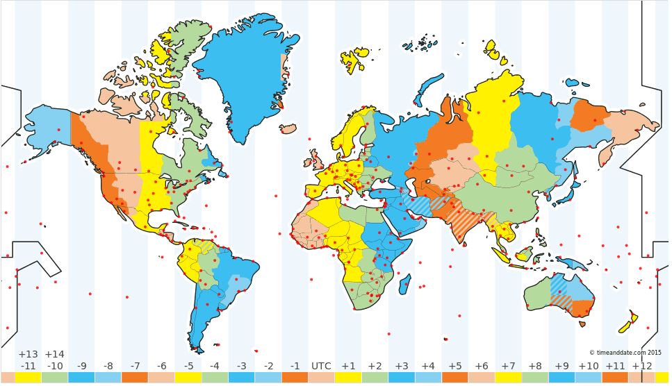
There are 24 or 25 time zones, depending on how you define them. A 'Time Zone' refers to any of these regions, where the same standard time is kept. A time zone is a geographical region that follows the same local time. The local time in a time zone is defined by its offest from Coordinated Universal Time(UTC), the world's time standard. UTC is not a time zone.
A country in the UTC+3 time zone is 3 hours ahead of UTC; in the UTC-8 time zone, clocks are 8 hours behind UTC.
Each time zone is then theoretically 15 degrees wide, corresponding to a one-hour difference in mean solar time. The shape of time zones is changed, in practice, to match internal and international borders. Civil time changes by one hour forward and backward respectively for every 15 degrees east or west of the Greenwich Meridian. One would need to divide the longitude, in degrees, by 15 to find the appropriate time zone, in hours. For example: At 150 degrees west (or 150° W) longitude, the time should be 150 degrees divided by 15 degrees = 10 hours behind Coordinated Universal Time (UTC) (or UTC-10). At 75 degrees east (or 75° E) longitude, the time would be 75 degrees divided by 15 degrees = 5 hours ahead of UTC/GMT (or UTC+5).
In practice time zones’ borders are irregular because of political factors. Time zones can be determined by how countries’ and states’ borders are positioned. Individual zone boundaries are not straight because they are adjusted for the convenience and desires of local populations. Moreover, some geographically large countries, such as India and China, use only one time zone but other large countries, such as Russia and the United States, have more than one time zone.
Many towns and cities around the world used to set clocks based on observing the sun and the stars. This occurred prior to the late 19th century. Dawn and dusk occur at different times at different places because of the Earth’s rotation. However, time differences between distant locations were barely noticeable because of long travel times and the lack of long-distance communications. The expansion of transport and communications, as well as trade globalization, during the 19th century created a need for a more unified time-keeping system.
Moreover, various meridians were also used for longitudinal reference among different countries. The Greenwich Meridian was adopted in 1884 as the initial or prime meridian for longitude and timekeeping. Read timeanddate.com’s article on the history of time zones for more detailed information on why we have time zones today.
Vapor trail:
The trail of clouds that billow from an airplane streaking across the sky can be mesmerizing for children and adults alike. Jet engine traffic has become so common that it's not unusual to see several lingering streaks in the afternoon. And though many consider the streaks beautiful against a bright blue sky, others are alarmed about them. Concerns range from the idea that these streaks could exacerbate global warming to more elaborate theories that the government has secretly been dumping harmful substances on the land.
Before we get into the various theories about the possible harmful effects, let's discuss the scientific explanation for these streaks. Jet engines spew out very hot air. And, because water vapor is one of the byproducts of the exhaust, the air is also very humid. However, high in the atmosphere where these jets fly, the air is typically very cold -- often lower than -40 degrees Fahrenheit. Additionally, the atmosphere up there is often of low vapor pressure, or the force exerted by a gas on the surrounding environment.
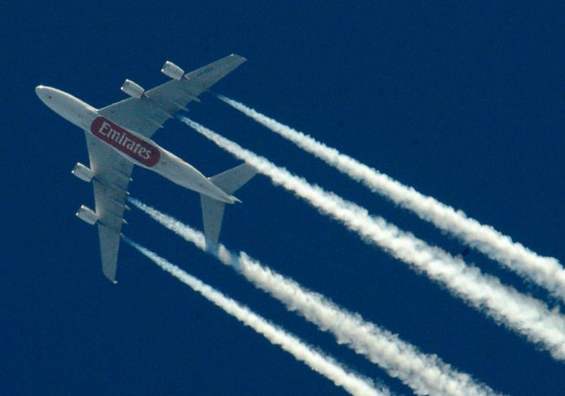
When a jet engine is spewing out hot, humid air into an atmosphere that is cold and has low vapor pressure, the result is condensation. The water vapor coming out of the engine quickly condenses into water droplets and then crystallizes into ice. The ice crystals are the clouds that form behind the engine. This is why the streaks are called contrails, short for "condensation trails." To help explain it, scientists liken it to seeing your breath on cold days. You may have noticed that puffs of breath dissipate quickly on dryer days. The same is true of contrails: When the atmosphere is more humid, the contrails linger, but when the atmosphere is dry, the contrails disappear more quickly.
This explanation makes sense. But, as author and airline pilot Patrick Smith tells readers, the contrails consist of not just ice crystals and water vapor but also other byproducts of engine exhaust. These include carbon dioxide, nitrogen oxides, sulfate particles and soot [source: Smith]. Some point out that these, in addition to the extra cloud cover, can have negative environmental effects. And conspiracy theorists have nicknamed contrails "chemtrails" under the suspicion that the government is taking advantage of this scientific phenomenon to secretly release other substances into the atmosphere.
Vertical speed indicator-VSI:
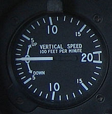
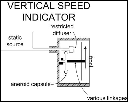
The final pitot-static instrument is the VSI, which indicates the vertical speed of the aircraft—i.e., the vertical component of the aircraft’s flight path—in hundreds of feet per minute. The sealed instrument case is connected to static pressure by way of a calibrated leak—i.e., a “slow bleeding” leak referred to as a restricted diffuser. Inside the case is a diaphragm that flexes in response to the pressure changes associated with a change in altitude; when the aircraft levels off, the diffuser equalizes the pressures on either side of the diaphragm causing the instrument readings to go to zero. The diffuser is designed to equalize pressures in approximately six to nine seconds.
The VSI is most accurate recording small changes in altitude, but becomes less accurate the greater the rate of descent or climb.
It is connected to the static port, so an alternate means of restoring static pressure for the altimeter if the static port becomes blocked is to deliberately break the glass on the VSI.
On the modern airplanes, the "Glass cockpit" (typically large LCD - screens, rather than the traditional-style analog dials and gauges), also known as "glass cockpit" is used, for example, the Boeing 737 Classic starting up 767-200 / 300, A380 and so on ). On these machines, electronic instruments, GPS-based displays are added to the pressure gauge is present only as an auxiliary instrument in case of any electrical malfunction.
Wing aspect ratio
Aspect ratio (AR) is a measure of how long and slender a wing is from tip to tip. The Aspect Ratio of a wing is defined to be the square of the span divided by the wing area and is given the symbol AR. For a rectangular wing, this reduces to the ratio of the span to the chord length.
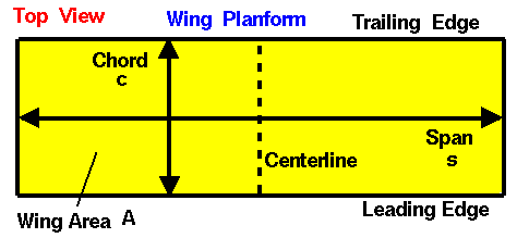
AR = s²/A, AR=s/c for rectangle
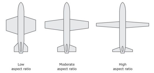
High aspect ratio wings have long spans (like high performance gliders), while low aspect ratio wings have either short spans (like the F-16 fighter) or thick chords (like the Space Shuttle).
Wing shapes and sizes of both birds and planes determine how they might perform or what they might be capable of (for example, gliding, sustained high speed and manoeuvrability). One way in which the shape of the wing can be described is through wing aspect ratio.
The ratio of the length of wings to their width is called aspect ratio. A high aspect ratio indicates long, narrow wings. A low aspect ratio indicates short, wide wings.
High aspect ratio wings
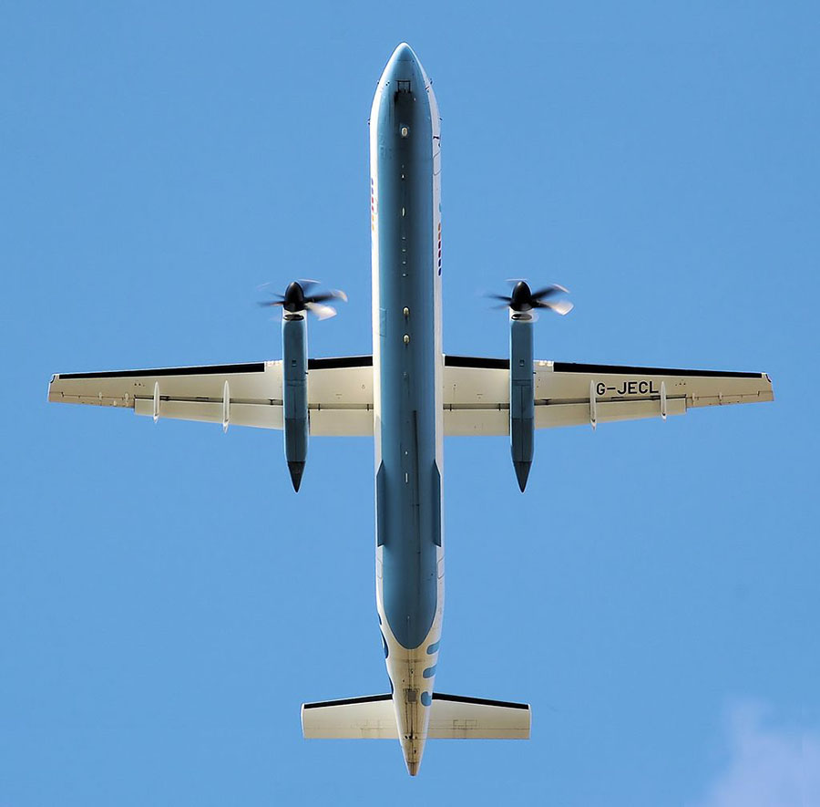
High aspect ratio wing (AR=12.8) of the Bombardier Dash 8 Q400
Stability: Long narrow wings give a plane or bird more stability. (It’s a bit like a tightrope walker who holds a long pole across their body as they walk along the rope – the extra ‘arm’ lengths help to balance the body by adding more mass to either side of it.) The trade-off is that this type of plane won’t be very manoeuvrable.
Less induced drag: Long, narrow wings also have less induced drag than shorter wider wings. Induced drag is created at the tips of the wings where the high pressure air from beneath the wing comes up over the wing tips into the low pressure zone. This meeting place of different air pressures becomes a turbulent area creating induced drag. Long narrow wings have less end edges (tips) and more stable wing area than shorter wider wings so they have less drag.
Less fuel consumption: Having less induced drag means there is less fuel consumption for planes and birds (fat consumption) so they can keep their speed for a longer time than short wide-winged fliers.
Low aspect ratio wings
Higher fuel consumption: Shorter wider-winged planes and birds have a bigger wing tip edge, which means more induced drag. This means they go slower unless they have extra power to counteract the drag. More fuel would be needed to keep them at a constant speed.
More manoeuvrable: The less stable wing area means the low aspect ratio wing is more manoeuvrable than the high aspect ratio wing. The peregrine falcon, for example, tucks its wings in (producing a low aspect ratio) for swift manoeuvrability.
Aspects ratios and wing loading are combined for different flying capabilities. For example, high aspect ratio combined with low wing loading is used for slow flight such as gliding or soaring.
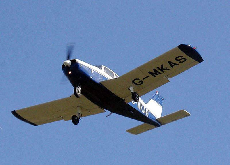
Low aspect ratio wing (AR=5.6) of a Piper PA-28 Cherokee
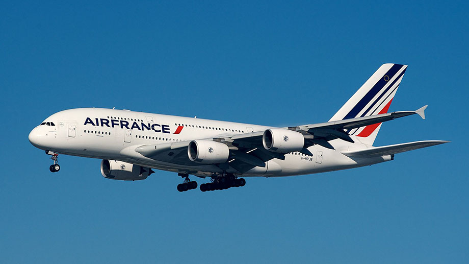
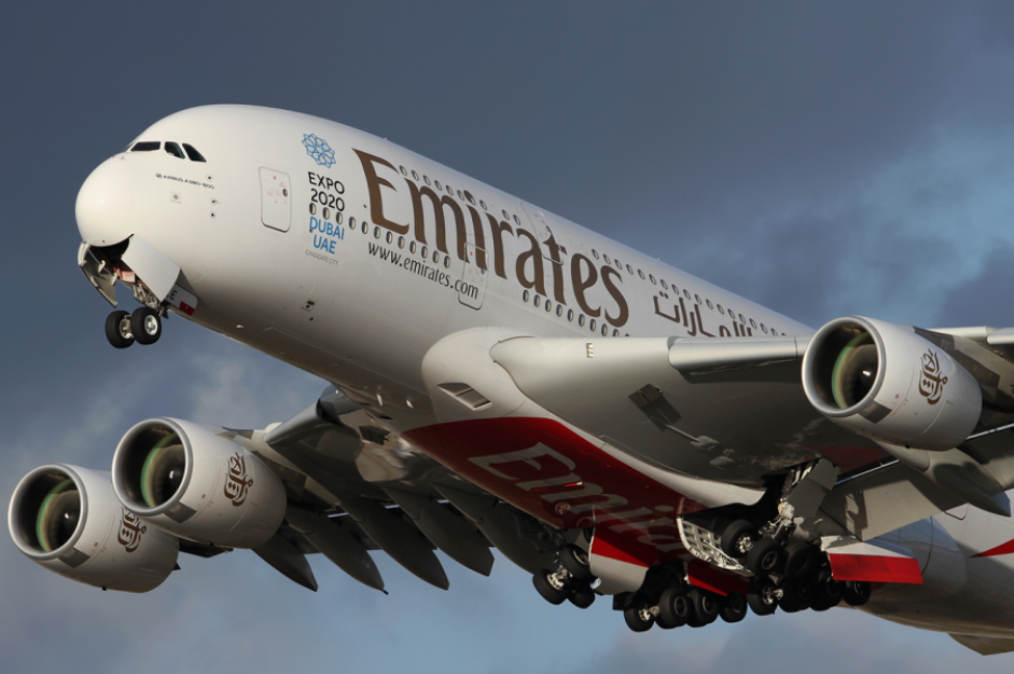
Airbus A380, wing aspect ratio: 7.8